


27
Background map vs. MapCreate map content
The background map includes: low-detail maps of the whole world (con-
taining cities, major lakes, major rivers, political boundaries); and me-
dium-detail maps of the United States.
The medium-detail U.S. maps contain: all incorporated cities; shaded
metropolitan areas; county boundaries; shaded public lands (such as
national forests and parks); some major city streets; Interstate, U.S.
and state highways; Interstate highway exits and exit services informa-
tion; large- and medium-sized lakes and streams and more than 60,000
navigation aids and 10,000 wrecks and obstructions in U.S. coastal and
Great Lakes waters
MapCreate custom maps include massive amounts of information not
found in the background map. MapCreate comes in a hunting topo and
non-topo version, and the non-topo program contains: the searchable
Points of Interest database, all the minor roads and streets, all the
landmark features (such as summits, schools, radio towers, etc.); more
rivers, streams, smaller lakes and ponds and their names.
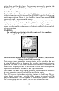
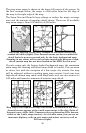
What's more important is the large-scale map detail that allows your
GPS unit to show a higher level of position accuracy. For example, the
background map would show you the general outline and approximate
shape of a coastline or water body, but the higher detail in MapCreate
shows the shoreline completely and accurately (finer detail). Many
smaller islands would not be included in the background map, but are
in MapCreate.
Special Hunting Details
MapCreate USA Hunting Topo version was developed specifically for
the iFINDER HUNT family. It contains all the higher detail in the non-
topo version, but the addition of topographical contour lines makes it
great for hikers, aviators and hunters.
MapCreate Topo contains an amazing amount of special information for
hunters, including: public hunting boundaries and their names from 47
states, along with game management unit boundaries from 22 states;
boundaries for state and federal wildlife refuges; state and federal for-
ests; city, state and federal parks; higher resolution hydrography (wa-
ter bodies) including intermittent streams; USGS 1:24000 scale topo
quadrangle map boundaries and more!
MapCreate USA Hunting Topo is the first GPS mapping software on
the market to offer this type of extensive hunting database.