


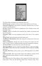

25
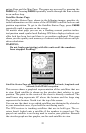
A circular representing your destination (waypoint) appears on the
screen as you approach the waypoint as shown on the screen below.
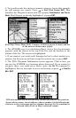
Travel Time is the time that it will take to reach your destination at
your present closing speed. Arrival Time is the local time it will be
when you arrive at the destination, based upon your present closing
speed and track.
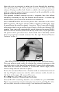
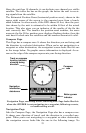
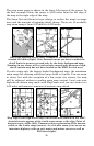
Navigation Page, going to cursor. Driver is headed east (a 68º track)
toward a cursor location 68º (bearing) away. The cross track error
range (white corridor) is 0.20 miles either side of the course.
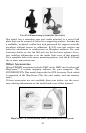
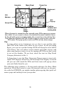
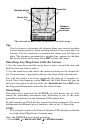
Map Page
The map screens show your course and track from a bird's-eye view. By
default, this unit shows the map with north always at the top of the screen.
(This can be changed using options in Advanced Mode. See the topic Map
Orientation, in Sec. 5.) If you're navigating to a waypoint, the map also
shows your starting location, present position, course line and destination.
NOTE:
When our text says, navigating to a waypoint, we really mean navi-
gation to any selected item, whether it is a waypoint, a map feature
or an item (like a restaurant) from the POI database.
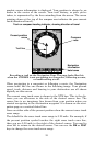
Using the map is as simple as pressing the
PAGES key. A screen similar to
those in following images appears. The arrow flashing in the center of the
screen is your present position. It points in the direction you're traveling.
The solid line extending from the arrow is your plot trail or path you've
taken. (Remember: flashing question mark on the arrow symbol or flashing
text displays means the iFINDER has not yet calculated a position.)
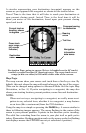
Bearing
arrow
Trail line
Cross track
error range
(off course
indicator)
Current track or
heading, shown
in degrees
Compass bearing
to destination
Navigation
information
data boxes
Destination
name