


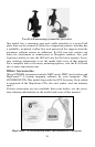

22
gation Page and the Map Page. The pages are accessed by pressing the
PAGES key. Pressing PAGES repeatedly scrolls through the four screens
in an endless loop.
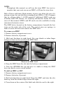
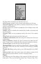
Satellite Status Page
The Satellite Status Page, shown in the following images, provides de-
tailed information on the status of the iFINDER's satellite lock-on and
position acquisition. To get to the Satellite Status Page, press
PAGES
repeatedly until it appears on the screen.
No matter what page you are on, a flashing current position indica-
tor/question mark symbol and flashing GPS data displays indicate sat-
ellite lock has been lost and there is no position confirmed. This page
shows you the quality and accuracy of current satellite lock-on and po-
sition calculation.
WARNING:
Do not begin navigating with this unit until the numbers
have stopped flashing!
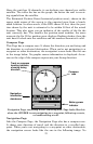
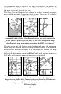
Satellite Status Page showing a 3D position fix (latitude, longitude and
altitude) with WAAS reception.
This screen shows a graphical representation of the satellites that are
in view. Each satellite is shown on the circular chart relative to your
position. The point in the center of the chart is directly overhead. The
small inner ring represents 45° above the horizon and the large ring
represents the horizon. North is at the top of the screen.
You can use the chart to see which satellites are obstructed by obstacles
in your immediate area, if you hold the unit facing north.
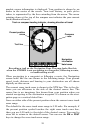
The GPS receiver is tracking satellites that are in bold type. The re-
ceiver hasn't locked onto a satellite if the number is grayed out. The
grayed out satellite is not being used to resolve your position. Beneath
the circular graph are bar graphs, one for each satellite in view.