


130
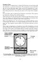
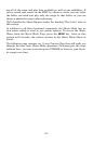
line pointing at your reference point. Remember to keep the iFINDER
level as you rotate it, so the back of the unit is parallel to the ground.
4. The line will travel all the way around the circle at least once, and
may go twice around the circle. Continue rotating your iFINDER in
time with the movement of the line until the words Calibration is Done
appear at the top of the screen. When you see this, you're finished! Your
iFINDER should now report accurate compass headings.
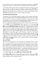
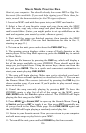
Set Hunting Waypoint
A waypoint is an electronic address, based on the latitude and longi-
tude of a position on the earth. Hunting Mode allows you to save way-
points and use a unique set of hunting symbols to represent them. Once
a waypoint exists, you can edit it by changing the symbol and name. We
describe that in more detail in the Advanced Mode section.
To save a hunting waypoint at your current location or cursor position:
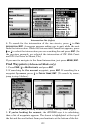
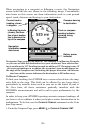
1. Press
ENT, and the NEW WAYPOINT menu appears. 2. Use the ↓ and ↑
keys to scroll through the list and select the waypoint type. 3. Press
ENT and the NEW WAYPOINT NAME menu appears. 4. To accept the default
name (which is numbered automatically), press
ENT and the waypoint
appears on screen with the default name. If you want a different name,
spell it out in the New Waypoint Name menu. The first character is
highlighted, so press ↑ or ↓ to scroll through a circular list containing
the alphabet, numbers and punctuation symbols. When the first char-
acter is correct, press → to move to the second character, then press ↑
or ↓ again to select the correct character. Press → to the next character
and repeat the process until you have spelled out the desired waypoint
name, then press
ENT.
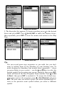
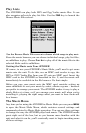
Scout Plots
The Scout Plot feature lets you map your own hunting areas. A scout
plot is a type of GPS data you can record that includes an area perime-
ter or boundary along with waypoints that mark game types. A scout
plot could be your immediate hunting area, a food plot, or the entire
piece of property you have permission to hunt on. Scout plots are saved
as part of a GPS Data File (with the *.usr suffix). This feature is espe-
cially useful on private lands, where property borders do not appear in
our mapping data. To start a new scouting session:
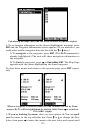
1. From the Map page, press
MENU|↓ to SCOUTING|ENT|ENT.
2. Use ↓ and ↑ to select the type of scouting session, then press
ENT.
(The default is Big Game, which determines the set of waypoint sym-
bols available for the scouting session.)