


26 iQue 3600a Que Applications Guide
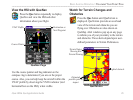
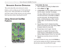
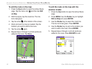
Terrain Information
The areas of the terrain appearing in red are predicted
to be within 100 feet above or below the altitude of
the aircraft. The yellow terrain areas are predicted to
be between the user-defined Caution Elevation and
100 feet below the altitude of the aircraft. By default,
the Caution Elevation is 1000 feet; therefore, the
areas in yellow are between 1000 feet and 100 feet
below the aircraft. The black areas are further than
the Caution Elevation. A projected point of impact is
marked with an X.
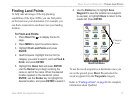
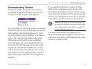
Obstacle Information
Obstacles are shown in QueTerrain and QueMap.
Standard aeronautical chart symbols are used for
lighted or unlighted obstacles taller than 200 feet
Above Ground Level (AGL). Refer to the Obstacle
Icons legend to the right.
Each obstacle is labeled with the altitude of the top of
the obstacle, or Mean Sea Level (MSL). Each obstacle
also lists the actual height of the obstacle, or Above
Ground Level (AGL) in parentheses.
Unlighted Obstacle below 1000 ft AGL.
Lighted Obstacle below 1000 ft AGL.
Unlighted Obstacle 1000 ft AGL and higher.
Lighted Obstacle 1000 ft AGL and higher.
Obstacle Icons
Terrain and Obstacle Color Code
The terrain and obstacles shown in QueTerrain and
the obstacles shown in QueMap follow the following
color code:
Red: Terrain or obstacle is within 100 feet of the
aircraft.
Yellow: Terrain or obstacle is between the user-
defined
Caution Elevation and 100 feet below the
aircraft.
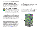
You can pan the map in QueTerrain just as you
pan the map in QueMap. See page 24 for more
information. To customize QueTerrain, refer to pages
36–37.
BASIC AVIATION OPERATION > FOLLOWING YOUR FLIGHT PLAN