


18 iQue 3600a Que Applications Guide
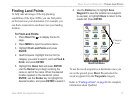
Aviation Nearest Categories
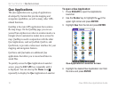
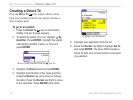
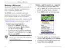
Press the NEAREST key to open the Aviation
Nearest page of QueFind. Continue pressing
NEAREST to scroll through the different Aviation
Nearest categories.
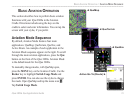
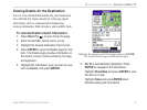
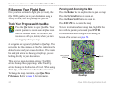
The Aviation Nearest categories are as follows:
Airport—nearest 15 with identifier, bearing, distance,
length of longest runway, and common traffic
advisory (CTAF) or tower frequency.
Weather (Airport Weather Sources)
—nearest
15 airport weather information sources, including
AWOS, ASOS, and ATIS.
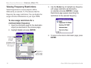
VOR (VHF Omnidirectional Radio Beacons)
—
nearest 15 with identifier, facility type (symbol),
bearing, distance, and frequency.
NDB (Non Directional Beacons)
—nearest 15 with
identifier, facility type (symbol), bearing, distance,
and frequency.
Intersection—nearest 15 with identifier, bearing, and
distance.
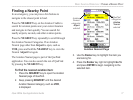
User (Waypoints)
—nearest 15 with name, symbol,
bearing, and distance.
ARTCC (Air Route Traffic Control Center)
—
nearest 5 with bearing, distance, and frequency.
FSS (Flight Service Station)—nearest 5 with
bearing, distance, frequency, and VOR (for duplex
operations).
Airspace—up to 15 (depending on number of alerts
provided) with name, time to entry (when applicable),
and status.
BASIC AVIATION OPERATION > FINDING A NEARBY POINT