


Garmin aera 500 Series Pilot’s Guide
190-01117-02 Rev. A
81
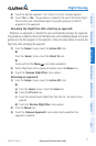
Hazard Avoidance
Overview GPS Navigation Flight Planning Hazard Avoidance Additional Features Appendices Index
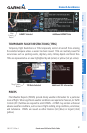
neXrAD Ab n o r M A l I t I e S
There are possible abnormalities regarding displayed NEXRAD images. Some, but
not all, of those include:
•Groundclutter
•Strobesandspuriousradardata
•Sunstrobes,whentheradarantennapointsdirectlyatthesun
•Militaryaircraftdeploymetallicdust(chaff)whichcancausealterationsinradar
scans
•Interferencefrombuildingsormountains,whichmaycauseshadows
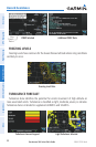
neXrAD lI MI tAtI on S
Certain limitations exist regarding the NEXRAD radar displays. Some, but not all, are
listed for the user’s awareness:
•NEXRAD basereectivity doesnot provide sufcientinformation todetermine
cloud layers or precipitation characteristics (hail vs. rain). For example, it is not
possible to distinguish between wet snow, wet hail, and rain.
•NEXRADbasereectivityissampledattheminimumantennaelevationangle.An
individual NEXRAD site cannot depict high altitude storms at close ranges, and
has no information about storms directly over the site.
•Radarcoverageonlyextendsto55°N.
•Anyprecipitationdisplayedbetween52°Nand55°Nisunknown.
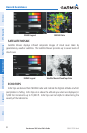
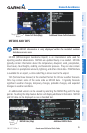
neXrAD In t e n S I t y
Colors are used to identify the different NEXRAD echo intensities (reflectivity)
measured in dBZ (decibels of Z). “Reflectivity” (designated by the letter Z) is the
amount of transmitted power returned to the radar receiver. The dBZ values increase
as returned signal strength increases. Precipitation intensity is displayed using colors
corresponding to the dBZ values.