


Garmin aera 500 Series Pilot’s Guide
190-01117-02 Rev. A
17
Overview
Overview GPS Navigation Flight Planning Hazard Avoidance Additional Features Appendices Index
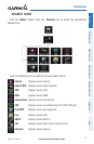
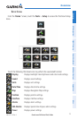
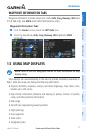
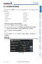
WAYPOINT INFORMATION TABS
Waypoint information is broken down into 5 tabs (
Info
,
Freq
,
Runway
,
WX
(aera
510 & 560 only), and
AOPA
(aera 550 & 560 Americas only)).
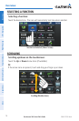
Waypoint Information Tabs:
➊
F
rom the 'Home' Screen, touch the WPT Info Icon.
➋
T
ouch the desired Tab (Info, Freq, Runway, WX
(optional)
, AOPA
(optional)
).
➊
➋
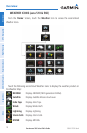
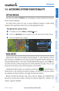
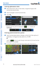
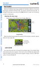
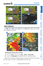
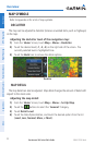
1.5 USING MAP DISPLAYS
NOTE: Refer to the GPS Navigation section for more information on Map
Display Setup.
Map displays are used extensively in the aera to provide situational awareness in
flight. Most aera maps can display the following information:
•
Airports, NAVAIDs, airspaces, airways, land data (highways, cities, lakes, rivers,
borders, etc.) with names
•Map Pointer information (distance and bearing to pointer,location of pointer,
name, and other pertinent information)
•Maprange
•Aircrafticon(representingpresentposition)
•Flightplanlegs
•Userwaypoints
•Trackvector
•Topographydata