


Garmin aera 500 Series Pilot’s Guide
190-01117-02 Rev. A
46
GPS Navigation
OverviewGPS NavigationFlight PlanningHazard AvoidanceAdditional FeaturesAppendicesIndex
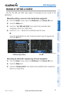
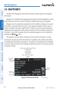
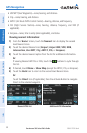
2.5 WAYPOINTS
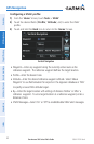
The WPT INFO (Waypoint Information) function provides airport and waypoint
information.
Waypoints are predetermined geographical positions (internal database) or pilot-
entered positions, and are used for all phases of flight planning and navigation.
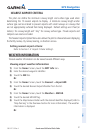
Waypoints can be selected by entering the ICAO identifier, entering the name of
the facility, or by entering the city name. As a waypoint identifier, facility name, or
location is entered, the aera’s Spell’N’Find™ feature scrolls through the database,
displaying those waypoints matching the characters which have been entered up to
that point. A direct-to navigation leg to the selected waypoint can be initiated by
pressing the Menu/ Icon.
The waypoint function allows the pilot to review airport information, runway
information, frequencies, AOPA information (if available), and weather information
(if available) by touching the desired tab. The pilot can manually enter the identifier
or the aera will choose the most appropriate identifier based on the current position
and phase of flight.
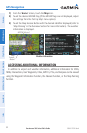
-Waypoint Identifier/Symbol/Type
-Facility Name
-City/State
-Fuel Available
-Elevation
Time Zone (UTC Offset)
-Region
Lat/Long
Info Tab
Option
Menu
Waypoint Information (Info Tab)
Bearing/
Distance
Waypoint
Identifier
Button