


Garmin aera 500 Series Pilot’s Guide
190-01117-02 Rev. A
49
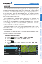
GPS Navigation
Overview GPS Navigation Flight Planning Hazard Avoidance Additional Features Appendices Index
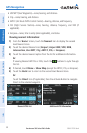
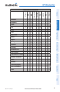
The Frequencies Box uses the descriptions and abbreviations listed in the follow-
ing table:
Communication Frequencies Navigation
Frequencies
Approach *
Arrival *
ASOS
ATIS
AWOS
Center
Class B *
Class C *
Clearance
Control
CTA *
Departure *
Gate
Ground
Helicopter
Multicom
Other
Pre-Taxi
Radar
Ramp
Terminal*
TMA *
Tower
TRSA *
Unicom
ILS
LOC
* May include Additional Information
Frequency Abbreviations
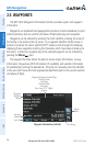
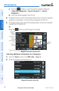
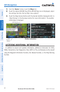
NEAREST INFORMATION
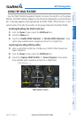
The aera provides a Nearest function which gives the pilot quick access to nearest
airport, weather, VOR, NDB, intersection, user waypoint, city, ARTCC, FSS, and airspace
information. If there are none available, “None Within 200 NM” is displayed.
The Nearest functions contain the following information.
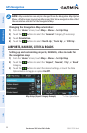
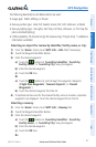
Airport• —identifier, bearing, distance, length of the longest runway, and common
traffic advisory (CTAF) or tower frequency.
Airport WX (Airport Weather)• —identifier, bearing, distance, METAR text (aera 510 &
560 only), and ATIS, AWOS, or ASOS frequency.
VOR (VHF Omnidirectional Radio Beacon)• —identifier, facility type (symbol), bearing,
distance, and frequency.
NDB (Non Directional Beacons)• —identifier, facility, type (symbol), bearing, distance,
and frequency.
Intersection• —identifier, bearing, and distance.
VRP (Visual Reporting Point) (Atlantic Unit Only)• —identifier, bearing, and distance.