


Garmin aera 500 Series Pilot’s Guide
190-01117-02 Rev. A
Appendix A
121
Overview GPS Navigation Flight Planning Hazard Avoidance Additional Features Appendices Index
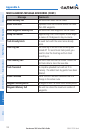
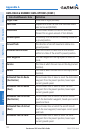
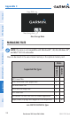
AIRSPACE MESSAGES
Message Comments
Inside Airspace
Inside the boundaries of the airspace.
Airspace Near and Ahead
Within two nautical miles of an airspace
and your current course takes you inside the
airspace.
Airspace Ahead, Within 10
Minutes
The projected course takes you inside an
airspace within the next 10 minutes or less.
Airspace Near, Within 2 nm
Within two nautical miles of an airspace but not
projected to enter it.
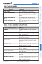
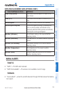
DATA FIELD & NUMERIC DATA OPTIONS
Data Field/Numeric Data Definition
Accuracy
The current accuracy of the GPS determined
location.
Altitude
The current altitude in geometric height above
Mean Sea Level (MSL).
Bearing
The compass direction from the present position
to a destination waypoint.
Course to Steer
The recommended direction to steer in order
to reduce cross-track error and return to the
course line.
Crosstrack Error
The distance the aircraft is off a desired course
in either direction, left or right.
Desired Track
The desired course between the active “from”
and “to” waypoints.
Distance (Destination)
The distance to the destination waypoint in the
Active Flight Plan
Distance (Next)
The distance to the next waypoint in the Active
Flight Plan.
En Route Safe Altitude
The recommended minimum altitude within ten
miles left or right of the desired course on a
active flight plan or direct-to.