


Garmin aera 500 Series Pilot’s Guide
190-01117-02 Rev. A
43
GPS Navigation
Overview GPS Navigation Flight Planning Hazard Avoidance Additional Features Appendices Index
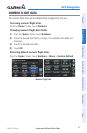
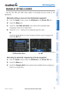
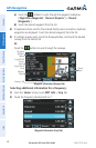
2.4 MAP DISPLAY SETUP
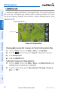
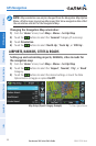
Map displays are used extensively in the aera to provide situational awareness in
flight. Most aera maps can display the following information:
•
Airports, NAVAIDs, airspaces, airways, land data (highways, cities, lakes, rivers,
borders, etc.) with names
•Map Pointer information (distance and bearing to pointer,location of pointer,
name, and other pertinent information)
•Maprange
•Aircrafticon(representingpresentposition)
•Flightplanlegs
•Userwaypoints
•Trackvector
•Topographydata
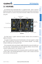
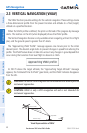
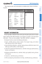
MAP ORIENTATION
Maps are shown in one of three different orientation options, allowing flexibility
in determining aircraft position relative to other items on the map (North Up) or for
determining where map items are relative to where the aircraft is going (Track Up), or
desired track up (DTK UP)).
•NorthUpalignsthetopofthemapdisplaytonorth(defaultsetting).
•TrackUpalignsthetopofthemapdisplaytothecurrentgroundtrack.
•DesiredTrack(DTK)Upalignsthetopofthemapdisplaytothedesiredcourse.