


Garmin aera 500 Series Pilot’s Guide
190-01117-02 Rev. A
47
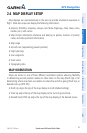
GPS Navigation
Overview GPS Navigation Flight Planning Hazard Avoidance Additional Features Appendices Index
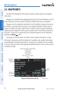
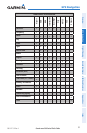
The following descriptions and abbreviations are used:
•Usagetype:Public,Military,orPrivate
•Runwaysurfacetype:Hard,Turf,Sealed,Gravel,Dirt,Soft,Unknown,orWater
•Runwaylightingtype:NoLights,PartTime,FullTime,Unknown,orPCLFreq(for
pilot-controlled lighting)
•COMAvailability:TX(transmitonly),RX(receiveonly),PT(parttime),* (additional
information available)
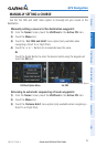
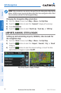
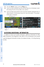
Selecting an airport for review by identifier, facility name, or city:
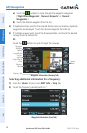
1)
From the 'Home' Screen, touch WPT Info > Info Tab (if necessary).
2)
Touch the Waypoint Identifier Button.
3)
Enter the desired waypoint:
a)
Touch the buttons to 'Search by Identifier', 'Search by
Facility Name', or 'Search by City' using the keypad.
b)
Enter the desired waypoint.
c)
Touch the OK Icon.
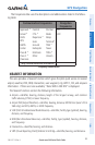
Or
:
a)
Touch the buttons to cycle through the waypoint categories
('Flight Plan Waypoints', 'Nearest Airports', or 'Recent
Waypoints'.)
b)
Touch the desired waypoint from the list.
4)
If duplicate entries exist for the entered facility name or location, duplicate
waypoints are displayed. Touch the desired waypoint from the list.
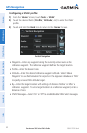
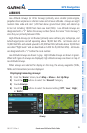
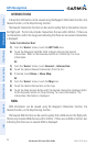
Selecting a runway:
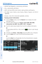
1)
From the 'Home' Screen, touch WPT Info > Runway Tab.
2)
Touch the Waypoint Identifier Button.
3)
Enter the desired waypoint:
a)
Touch the buttons to 'Search by Identifier', 'Search by
Facility Name', or 'Search by City' using the keypad.
b)
Enter the desired waypoint.
c)
Touch the OK Icon.
Or: