


Garmin aera 500 Series Pilot’s Guide
190-01117-02 Rev. A
18
Overview
OverviewGPS NavigationFlight PlanningHazard AvoidanceAdditional FeaturesAppendicesIndex
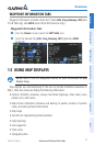
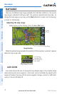
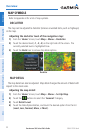
MAP RANGE
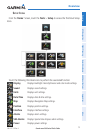
There are 23 different map ranges available, from 200 feet to 800 nm. The current
map range is indicated in the lower right. The scale bar represents the map scale. To
change the map range on any map, use the Out or In Icons to zoom ‘out’ (increasing),
or zoom ‘in‘ (decreasing).
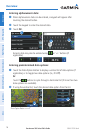
Adjusting the map range:
While viewing a Map Display, touch the In or Out Icons.
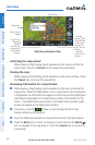
Navigation Map
Map Range
Range
Icons
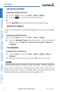
When the selected range exceeds the resolution of the map data, ‘overzoom’ appears
below the map range scale.
Map Range/Overzoom
Scale Bar Rep-
resenting a Map
Scale of 3 nm Per
Scale Width.
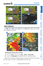
AUTO ZOOM
Auto Zoom allows the aera to change the map display range to the smallest range
clearly showing the active waypoint. Auto Zoom can be overridden by adjusting the
range and remains that way until the active waypoint changes, a terrain or traffic alert
occurs, or the aircraft takes off.