


Garmin aera 500 Series Pilot’s Guide
190-01117-02 Rev. A
103
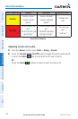
Hazard Avoidance
Overview GPS Navigation Flight Planning Hazard Avoidance Additional Features Appendices Index
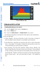
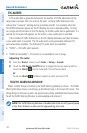
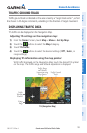
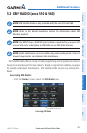
TRAFFIC GROUND TRACK
Traffic ground track is indicated on the aera screen by a “target track vector”, a short
line shown in 45-degree increments, extending in the direction of target movement.
DISPLAYING TRAFFIC DATA
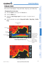
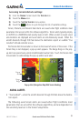
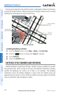
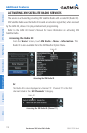
TIS traffic can be displayed on the Navigation Map.
Adjusting TIS settings on the navigation map:
1)
From the ‘Home’ Screen, touch Map > Menu > Set Up Map.
2)
Touch the buttons to select the Map Category.
3)
Touch TIS Traffic.
4)
Touch the buttons to select the desired settings ('Off', 'Auto', or
range settings).
Displaying TIS information using the map pointer:
With traffic displayed on the Navigation Map, touch the desired TIS symbol
on the map. The traffic range and altitude separation is displayed.
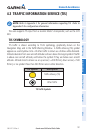
Traffic
Warning
Window
Range
Rings
TIS (Navigation Map)
Traffic Range
and Altitude
Separation using
Map Pointer
Traffic Ground
Track