


Garmin aera 500 Series Pilot’s Guide
190-01117-02 Rev. A
Appendix C
132
OverviewGPS NavigationFlight PlanningHazard AvoidanceAdditional FeaturesAppendicesIndex
GARMIN DATABASE INFORMATION
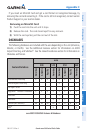
The following databases are provided by Garmin:
• WorldwideBasemap
• SafeTaxi
• Terrain
• Obstacle
The basemap database contains data for the topography and land features, such as
rivers, lakes, and towns. It is updated only periodically, with no set schedule. There is
no expiration date.
The terrain database contains the terrain mapping data. The database is updated
periodically and has no expiration date.
The obstacle database contains data for obstacles, such as towers, that pose a
potential hazard to aircraft. Obstacles 200 feet and higher are included in the obstacle
database. It is very important to note that not all obstacles are necessarily charted and
therefore may not be contained in the obstacle database. This database is updated on
a 56-day cycle and does not expire.
NOTE:
The data contained in the terrain and obstacle databases comes from
government agencies. Garmin accurately processes and cross-validates the
data, but cannot guarantee the accuracy and completeness of the data.
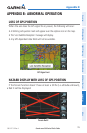
The Safe Taxi database contains detailed airport diagrams for selected airports.
These diagrams aid in following ground control instructions by accurately displaying
the aircraft position on the map in relation to taxiways, ramps, runways, terminals, and
services. This database is updated on a 56-day cycle and does not expire.
gA r M I n AvI AtI on DA t A b A S e up D A t e S
NOTE:
For automotive map updates refer to http://my.garmin.com.
The Garmin aviation database updates can be obtained by visiting the ‘flyGarmin’
website (www.fly.garmin.com).
After the databases have been updated, check that the appropriate databases are
initialized and displayed on the splash screen during power-up.