


Garmin aera 500 Series Pilot’s Guide
190-01117-02 Rev. A
80
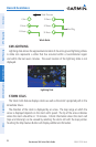
Hazard Avoidance
OverviewGPS NavigationFlight PlanningHazard AvoidanceAdditional FeaturesAppendicesIndex
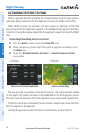
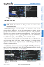
Accessing the XM Radio ID
Radio ID
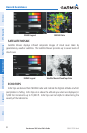
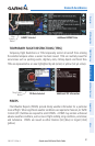
XM SATELLITE WEATHER PRODUCTS
NEXRAD
NEXRAD (NEXt-generation RADar), is a network of 158 high-resolution Doppler
radar systems that are operated by the National Weather Service (NWS). NEXRAD data
provides centralized meteorological information for the continental United States and
selected overseas locations. The maximum range of a single NEXRAD radar site is 250
nm. In addition to a wide array of services, the NEXRAD network provides important
information about severe weather and air traffic safety.
NEXRAD data is not real-time. The lapsed time between collection, processing, and
dissemination of NEXRAD images can be significant and may not reflect the current
radar synopsis. Due to the inherent delays and the relative age of the data, it should
be used for long-range planning purposes only. Never use NEXRAD data or any radar
data to penetrate hazardous weather. Rather, use it in an early-warning capacity of
pre-departure and enroute evaluation.
Composite data from all the NEXRAD radar sites in the United States is shown. This
data is composed of the maximum reflectivity from the individual radar sweeps. The
display of the information is color-coded to indicate the weather severity level.
The display of radar coverage is always active when NEXRAD is selected. Areas
where NEXRAD radar coverage is not currently available or is not being collected are
indicated in grayish-purple. Radar capability exists in these areas, but it is not active
or is off-line.