


Garmin aera 500 Series Pilot’s Guide
190-01117-02 Rev. A
57
GPS Navigation
Overview GPS Navigation Flight Planning Hazard Avoidance Additional Features Appendices Index
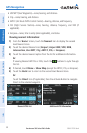
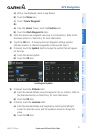
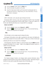
a)
With a map displayed, touch a map feature.
b)
Touch the Menu Icon.
c)
Touch 'Create Waypoint'.
Or:
a)
From the ‘Home’ Screen, touch the Position Icon.
b)
Touch the Mark Waypoint Button.
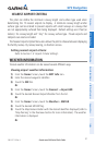
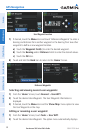
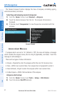
2)
Enter the desired user waypoint name (up to 10 characters). Refer to the
Overview Section on 'Data Entry' for more information.
3)
Touch the OK Icon. If changing the User Waypoint settings (symbol,
altitude, location, or reference waypoints) continue with Step 4.
4)
If desired, touch the Symbol Field to change the symbol that will appear
on the map.
a)
Touch the desired symbol.
b)
Touch the OK Icon.
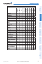
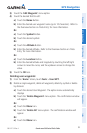
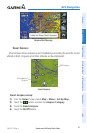
User Waypoint Symbols
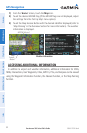
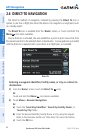
5)
If desired, touch the Altitude Field
a)
Enter the desired altitude using the keypad or the +/- buttons. Refer to
the Overview Section on 'Data Entry' for more information.
b)
Touch the OK Icon.
6)
If desired, touch the Location Field.
a)
Enter the desired latitude and longitude by touching the left/right
arrows to move the cursor, and the up/down arrows to change the
value.
b)
Touch the OK Icon.