


Garmin aera 500 Series Pilot’s Guide
190-01117-02 Rev. A
91
Hazard Avoidance
Overview GPS Navigation Flight Planning Hazard Avoidance Additional Features Appendices Index
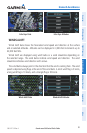
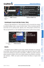
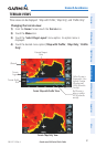
WATER TEMPERATURE
The surface temperatures of coastal and large inland bodies of water are displayed.
Water Temperature Data
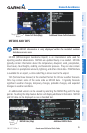
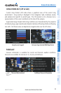
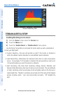
USING XM SATELLITE WEATHER PRODUCTS
XM Weather Products can be displayed on the Navigation Map and individually on
the Weather Maps.
The setup menu for the Navigation Map controls the map range settings above which
weather products are decluttered from the display. If a map range larger than the
weather product map range setting is selected, the weather product data is removed
from the map. For weather products such as Lightning, and Storm Cells, the weather
product is displayed when a map range “smaller” than the weather product map range
setting is selected (Satellite Mosaic works inversely). The menu also provides a means
for enabling/disabling display of ‘Airmets’, ‘Sigmets’, ‘Weather Data’, ‘NEXRAD’, and/
or ‘Fronts’ on the Navigation Map.
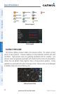
Additional information about the following can be displayed by panning over the
display on map:
•StormCells
•SIGMETs
•AIRMETs
•METARs
•TFRs
Additional information is also available for the following weather products on the
Weather Map (not displayed on the Navigation Map):
•Forecast •PIREPs