


Garmin aera 500 Series Pilot’s Guide
190-01117-02 Rev. A
19
Overview
Overview GPS Navigation Flight Planning Hazard Avoidance Additional Features Appendices Index
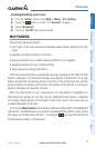
Enabling/disabling auto zoom:
1)
From the 'Home' Screen, touch Map > Menu > Set Up Map.
2)
Touch the buttons to select the 'General' Category.
3)
Touch 'Autozoom'.
4)
Touch the 'On/Off' Data Option Button.
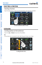
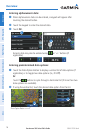
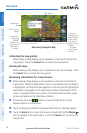
MAP PANNING
Map panning allows the pilot to:
•Viewpartsofthemapoutsidethedisplayedrangewithoutadjustingthemap
range
•Highlightandselectlocationsonthemap
•Reviewinformationforaselectedairport,NAVAIDoruserwaypoint
•Designatelocationsforuseinightplanning
•Viewairspaceandairwayinformation
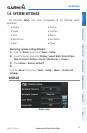
When the panning function is selected by touching anywhere on the Map, the Map
Pointer is displayed. An Information Window also appears at the bottom of the map
display showing the the bearing, distance and time to the pointer from the aircraft’s
present position, the elevation of the land at the position of the pointer, or the object’s
(airports, obstacles, etc) elevation, if known.
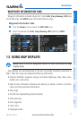
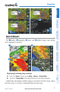
When the Map Pointer is over a map feature, the map feature is highlighted, an
information box appears on the map, and the highlighted map feature is displayed
on the Map Feature Button at the bottom of the screen (even if the name was not
originally displayed on the map).
Touching the Map Feature Button displays additional information for the highlighted
map feature. If multiple features are present at the Map Pointer position, green arrows
will appear on the Map Feature Button. Touching the
will cycle through the list
of map features present at that position.