


Garmin aera 500 Series Pilot’s Guide
190-01117-02 Rev. A
51
GPS Navigation
Overview GPS Navigation Flight Planning Hazard Avoidance Additional Features Appendices Index
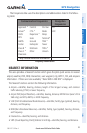
NEAREST AIRPORT CRITERIA
The pilot can define the minimum runway length and surface type used when
determining the 15 nearest airports to display. A minimum runway length and/or
surface type can be entered to prevent airports with small runways or runways that
are not appropriately surfaced from being displayed. Default settings are 0 feet (or
meters) for runway length and "Any" for runway surface type. Private airports and
Heliports can also be included.
The Nearest Airports Option Menu also allows the pilot to choose between displaying
the facility names, city names, bearing, or direction arrows.
Setting nearest airport criteria:
Refer to Section 1.4 'Airport Criteria Settings'.
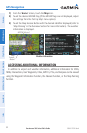
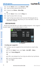
WEATHER INFORMATION
Textual weather information can be viewed several different ways.
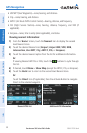
Viewing airport weather information:
1)
From the ‘Home’ Screen, touch the WPT Info Icon.
2)
Enter the desired waypoint identifier.
3)
Touch the WX Tab.
Or
:
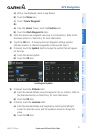
1)
From the ‘Home’ Screen, touch the Nearest > Airport WX.
2)
Touch the desired Nearest Airport Weather from the list.
Or
:
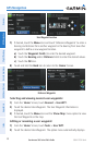
1)
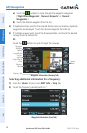
From the ‘Home’ Screen, touch the Weather > METAR.
2)
Touch the desired METAR flag.
3)
Touch the Map Feature Button with the desired identifier displayed (refer to
'Map Panning' in the Overview Section for more information). The weather
information is displayed.
Or
: