


Garmin aera 500 Series Pilot’s Guide
190-01117-02 Rev. A
52
GPS Navigation
OverviewGPS NavigationFlight PlanningHazard AvoidanceAdditional FeaturesAppendicesIndex
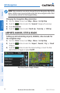
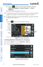
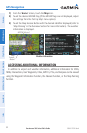
1)
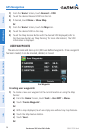
From the ‘Home’ Screen, touch the Map Icon.
2)
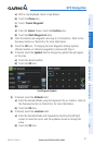
Touch the desired METAR Flag (If the METAR flags are not displayed, adjust
the settings from the 'Set Up Map' menu option).
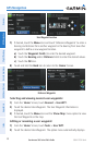
3)
Touch the Map Feature Button with the desired identifier displayed (refer to
'Map Panning' in the Overview Section for more information). The weather
information is displayed.
METAR Selected
Weather Information
Map
Feature
Button
ACCESSING ADDITIONAL INFORMATION
In addition to airport and weather information, additional information for VORs,
NDBs, Intersections, User Waypoints, Cities, ARTCCs, FSSs, and Airspace can be viewed
using the Waypoint Information function, the Nearest function, or the Map Panning
function.