


Garmin aera 500 Series Pilot’s Guide
190-01117-02 Rev. A
ii
Table of Contents
2.3 Vertical Navigation (VNAV) ....................................................................................40
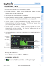
Using the VNAV Feature .....................................................................................................41
2.4 Map Display Setup ..................................................................................................43
Map Orientation................................................................................................................. 43
Airports, Navaids, Cities & Roads ........................................................................................44
Airways ..............................................................................................................................45
2.5 Waypoints ................................................................................................................46
Nearest Information ........................................................................................................... 49
Weather Information .......................................................................................................... 51
Accessing Additional information ........................................................................................ 52
2.6 Direct-to Navigation ...............................................................................................64
Section 3 Flight Planning ............................................................................. 67
3.1 Introduction .............................................................................................................67
Data Fields ......................................................................................................................... 67
3.2 Flight Plan Creation ................................................................................................68
Adding Waypoints to an Existing Flight Plan ........................................................................ 70
3.3 Flight Plan Storage .................................................................................................71
3.4 Flight Plan Activation .............................................................................................72
Editing Speed and Fuel Flow ............................................................................................... 72
Copying Flight Plans ........................................................................................................... 73
Deleting Flight Plans ..........................................................................................................73
Inverting a Flight Plan ........................................................................................................ 74
3.5 Approaches ..............................................................................................................75
Selecting an Approach ........................................................................................................ 76
Activating Vectors-to-Final .................................................................................................. 78
Section 4 Hazard Avoidance ......................................................................... 79
4.1 XM
®
Weather (aera 510 & 560) ...............................................................................79
Activating Services .............................................................................................................79
XM Satellite Weather Products ............................................................................................ 80
Using XM Satellite Weather Products .................................................................................. 91
4.2 Terrain ......................................................................................................................94
Terrain Information ............................................................................................................. 95
Obstacle Information ..........................................................................................................95
Terrain and Obstacle Color Code......................................................................................... 96
Terrain Views ......................................................................................................................97
Terrain Alerts & Setup ......................................................................................................... 98
4.3 Traffic Information Service (TIS) ..........................................................................101
TIS Symbology .................................................................................................................. 101
TIS Alerts ......................................................................................................................... 102
Traffic Ground Track ......................................................................................................... 103
Displaying Traffic Data ......................................................................................................103