


Garmin aera 500 Series Pilot’s Guide
190-01117-02 Rev. A
Appendix A
123
Overview GPS Navigation Flight Planning Hazard Avoidance Additional Features Appendices Index
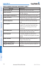
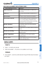
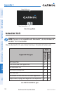
DATA FIELD & NUMERIC DATA OPTIONS (CONT.)
Data Field/Numeric Data Definition
Time of Day (Local)
The current time and date in 12-hour or 24-
hour format.
Time (UTC)
The current time and date in Universal (UTC)
time.
Vertical Speed
The rate of climb or descent (GPS-derived).
Vertical Speed Required
The vertical speed necessary to decend/climb
from a current position and altitude to the
previously selected VNAV position and altitude,
based upon current groundspeed.
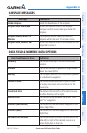
Weather (Altimeter)
The altimeter setting at the nearest METAR
reporting station.
Weather (Dew Point)
The dew point at the nearest weather reporting
station.
Weather (Rel. Humidity)
The relative humidity at the nearest weather
reporting station.
Weather (Temperature)
The temperature at the nearest weather
reporting station.
Weather (Wind)
The wind speed and direction at the nearest
weather reporting station.
AURAL ALERTS
TRAFFIC
“Traffic”—TIS traffic alert received.•
“Traffic Not Available”—TIS service is not available or out of range.•
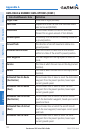
TERRAIN
“Five Hundred”—when the aircraft descends through 500 feet above the destina-•
tion airport.