


Garmin aera 500 Series Pilot’s Guide
190-01117-02 Rev. A
96
Hazard Avoidance
OverviewGPS NavigationFlight PlanningHazard AvoidanceAdditional FeaturesAppendicesIndex
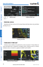
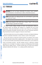
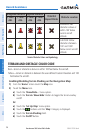
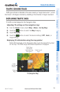
Unlighted Obstacle Lighted Obstacle
Potential
Impact Points
Obstacle Location
< 1000’
AGL
> 1000’
AGL
< 1000’
AGL
> 1000’
AGL
WARNING: Red
obstacle is above or
within 100’ below
current aircraft
altitude
CAUTION: Yellow
obstacle is between
100’ and 1000’
below current aircraft
altitude
Terrain Obstacle Colors and Symbology
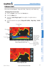
TERRAIN AND OBSTACLE COLOR CODE
Red—terrain or obstacle is above or within 100 feet below the aircraft.
Yellow—terrain or obstacle is between the user-defined Caution Elevation and 100
feet below the aircraft.
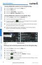
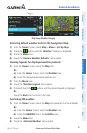
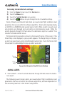
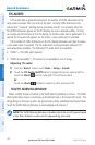
Enabling/Disabling Terrain Shading on the Navigation Map:
1)
From the ‘Home’ Screen touch the Map Icon.
2)
Touch the Menu Icon.
a)
Touch the 'Show/Hide...' menu option.
b)
Touch the Terrain 'Show/Hide' Button to toggle the terrain overlay
on/off.
Or:
a)
Touch the 'Set Up Map' menu option.
b)
Touch the buttons until the 'Map' Category is displayed.
c)
Touch the Terrain Shading Field.
d)
Touch the On/Off Button.