


Garmin aera 500 Series Pilot’s Guide
190-01117-02 Rev. A
94
Hazard Avoidance
OverviewGPS NavigationFlight PlanningHazard AvoidanceAdditional FeaturesAppendicesIndex
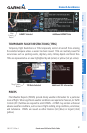
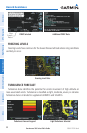
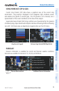
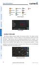
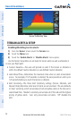
4.2 TERRAIN
WARNING:
Do not use Terrain information for primary terrain avoidance.
Terrain information is intended only to enhance situational awareness.
NOTE:
Terrain data is not displayed when the aircraft latitude is greater than
75
°
North or 60
°
South.
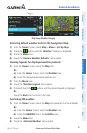
NOTE:
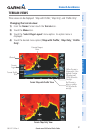
Terrain depicted in the Profile View is always “ahead” of the aircraft,
and will change as ground track changes.
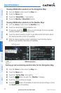
The Terrain function displays altitudes of terrain and obstructions relative to
the aircraft position and altitude with reference to a database that may contain
inaccuracies. Terrain and obstructions are shown only if they are in the database.
Terrain and obstacle information should be used as an aid to situational awareness.
They should never be used to navigate or maneuver around terrain.
Note that all obstructions may not be available in the terrain and obstacle database.
No terrain and obstacle information is shown without a valid 3-D GPS position.
The aera GPS receiver provides the horizontal position and altitude of the aircraft.
Aircraft GPS altitude is derived from satellite position. GPS altitude is then converted
to a mean sea level (MSL)-based altitude (GPS-MSL altitude) and is used to determine
terrain and obstacle proximity. GPS-MSL altitude accuracy is affected by satellite
geometry, but is not subject to variations in pressure and temperature that normally
affect pressure altitude sensors. GPS-MSL altitude does not require local altimeter
settings to determine MSL altitude. It is a widely-used MSL altitude source.