


Garmin aera 500 Series Pilot’s Guide
190-01117-02 Rev. A
40
GPS Navigation
OverviewGPS NavigationFlight PlanningHazard AvoidanceAdditional FeaturesAppendicesIndex
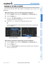
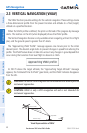
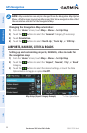
2.3 VERTICAL NAVIGATION (VNAV)
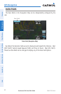
The VNAV function provides settings for the vertical navigation. These settings create
a three-dimensional profile from the present location and altitude to a final (target)
altitude at a specified location.
When the VNAV profile is defined, the pilot is informed of the progress by message
alerts. The teal bar on the HSI (when displayed) shows the VNAV profile.
The Vertical Navigation feature is only available when navigating a Direct To or flight
plan, and the ground speed is greater than 35 knots.
The “Approaching VNAV Profile” message appears one minute prior to the initial
descent point. The descent angle locks to prevent changes in speed from altering the
profile. The VNAV feature does not take into account any changes in groundspeed that
occur during the transition from level flight to descent or climb.
At 500 ft above the target altitude, the “Approaching Target Altitude” message
appears, the ‘Estimated Time To VNAV’ goes blank, and the VNAV indicator disappears
from the HSI.
CAUTION: The aera is a VFR navigation tool and should not be used to perform
instrument approaches.
CAUTION: VNAV is only a VFR navigation aid and is not intended for
instrument approaches.
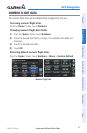
VNAV Profile
Glide Ratio to Target
Distance to Target
Distance to Profile
Target Altitude
Airport
Visual Representation of VNAV