


20
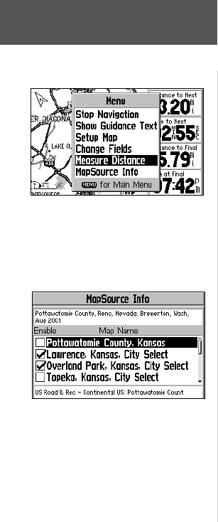
Measure Distance—allows you to measure the bearing and distance between any
two points you choose on the Map Page. Also displays the latitude and longitude of the
pointer.
To measure the distance between two points:
1. With the Map Page Options displayed, select ‘Measure Distance’ and press ENTER.
An on-screen pointer will appear on the map display at your current location.
2. Use the ROCKER KEYPAD to move the panning pointer to the desired reference
point (i.e., the point you want to measure from) and press ENTER.
3. Move the pointer to the point you want to measure to. The distance and direction
from the reference point is shown on the top of the Map Page.
4. Press the QUIT key (or select ‘Stop Measure Distance’ on the Map Page Options
menu) to exit the measuring function and return to normal operation.
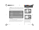
MapSource Info—shows which maps have been downloaded from the MapSource
City Select CD-ROM (or an optional MapSource-family CD-ROM). MapSource map
data supplements the built-in map with additional detail, including residential streets,
better routing capability and points of interest. Each downloaded map is described by
name, and may be deselected if you wish to retain the map in memory but not display
is on the map page. This is particularly useful if the same map area is downloaded from
more than one MapSource-family product. (When a map is selected, the boundary for
the map is shown on the Map Page as a gray shaded outline box.)
To view MapSource info and enable/disable maps:
1. With the Map Page Options displayed, select ‘MapSource Info’ and press ENTER.
2. Use the ROCKER KEYPAD to scroll through the list of downloaded maps.
3. To select/deselect a map, use the ROCKER KEYPAD to highlight the desired map
and press ENTER. The map is selected and will be displayed on the Map Page when
the box adjacent to the map name is checked.
Reference
Map Page
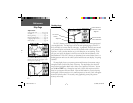
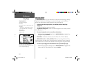
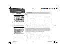
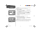
Use the ‘Measure Distance’ option to measure
distance and bearing between any two map
locations. A pointer and “rubber-band” will
appear, along with display of bearing and
distance between points at the top of the page.
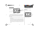
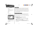
Use the ‘MapSource Info’ screen to enable or
disable any map data you have downloaded
to your GPS V. Maps are enabled when the
box adjacent to the map name is checked.
GPS V OM.indd 20 5/7/2003, 8:53:02 AM