


Introduction and controls 1-1
JJM 18 05 16/00 Last amend: November 1999 – NAS
Introduction
This Jaguar navigation system assists the
driver by providing a route to a selected
destination. Guidance is given by means
of audible instructions (voice guidance),
complemented by map and turn
information which is displayed on an
LCD screen on the front panel of the
unit. Digital map information is held on a
compact disc (CD), which is loaded into
the navigation control unit housed in the
luggage compartment.
The system has an extremely
comprehensive range of features, yet is
easy to use. Some time spent reading this
handbook will ensure that the best
results are obtained.
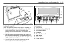
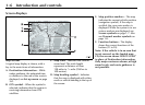
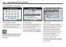
The LCD display provides full
information for operating the system by
means of menus, text prompts and map
displays. Screen selections are made by
the controls on the front panel.
About this handbook
This handbook shows the on-screen
menus, explains how to operate the
controls, and gives an example showing
how to set a destination. After becoming
familiar with the controls, follow the
on-screen menus and prompts, to
operate the system as required.
The Navigation Menu Structure card
supplied with this handbook can be used
to find a particular menu. This
information is repeated on page 2-5.
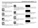
Some menu items can be selected
entirely by using the function buttons (F1
to F3). These sequences are shown at the
top of the relevant pages, for example:
Address input (F1 → F1 → F2).
How the system works
The system uses signals from the Global
Positioning System (GPS) satellites, which
allow the approximate vehicle position
to be calculated. This is combined with
information from vehicle sensors and the
database on the map CD, to establish the
true vehicle position.
!
WARNING:
1. The Database reflects reality as
existing before you received the
Database and it comprises data
and information from
government and other sources,
which may contain errors and
omissions. Accordingly, the
Database may contain inaccurate
or incomplete information due to
the passage of time, changing
circumstances, and due to the
nature of the sources used. The
Database does not include or
reflect information on – inter alia
– neighborhood safety; law
enforcement; emergency
assistance; construction work;
road or lane closures; vehicle or
speed restrictions; road slope or
grade; bridge height, weight or
other limits; road or traffic
conditions; special events; traffic
congestion; or travel time.
2. Only operate, adjust or view the
system when it is safe to do so.
1 Introduction and controls