


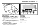
1-6 Introduction and controls
JJM 18 05 16/00 Last amend: November 1999 – NAS
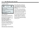
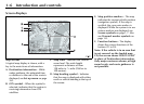
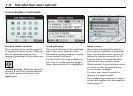
Screen displays
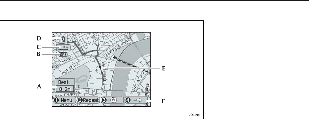
Map screens
A typical map display is shown, with a
key to the main items of information.
A. Destination information
– While
under guidance, the estimated time
or distance to the end of the route is
displayed, see
Set up menu
on page
3-6.
B. GPS symbol
– When the symbol is
selected, indicates that the system is
receiving information from GPS
satellites.
C. Map scale
– Indicates the current
zoom level. The scale length
represents a distance of from
128 miles to
1
/
16
mile (256 km to
100 metres).
D. Map heading symbol
– Indicates
that the map is displayed with either
north or vehicle heading to the top of
the screen.
E. Map position markers
– The map
indicates the current vehicle position
(navigation symbol). If the map is
scrolled, the cross-wire marker is
displayed. While the system is in use
various markers are displayed, see
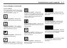
Screen symbols
on page 1-7. Also
see
Personal marker symbols
on
page 1-8.
F. Function buttons
– The display
shows the current functions of the
buttons (F1 to F4).
Note: If the vehicle is in an area that
is not covered on the loaded map
CD, the screen shows ‘ROUTE ONLY’
in place of Destination information.
Only major routes are shown, at high
zoom levels, and route guidance is
not possible.