


49
NRST/FIND
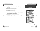
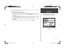
Nearest Pages ( Aviation Mode)
The GPSMAP 196’s NRST/FIND key provides different information, depending upon the operat-
ing mode the unit is currently in. In Aviation Mode, it operates as a NRST key, providing detailed
information on the fi fteen nearest airports, airport weather sources, VORs, NDBs, intersections and user
waypoints within 200 miles of your present position. Information regarding the fi ve nearest FSS (fl ight
service station) and center (ARTCC) points of communication, along with associated frequency(s) is
available, as well. When an airspace alert is provided, the Nearest Pages will even provide additional
detail about the airspace.
In the Land or Water modes, this same key functions as a FIND key allowing you to search for
cities, highway exits and (with optional MapSource data) points of interest, street addresses/intersec-
tions, geographic points and tide stations. See page 54 for more information on FIND key operations.
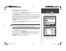
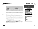
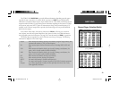
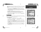
The Nearest Pages are organized by a series of fi le tabs across the top of the page. The following
information is displayed on the Nearest Pages:
Airport fi fteen nearest with identifi er, bearing to and distance, length of longest runway, and
common traffi c advisory (CTAF) or tower frequency.
Wx fi fteen nearest airport weather information sources, including AWOS, ASOS and
ATIS.
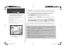
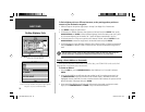
VOR fi fteen nearest with identifi er, facility type (symbol), bearing to and distance, fre-
quency, and co-located weather broadcast availability.
NDB fi fteen nearest with identifi er, facility type (symbol), bearing to and distance, fre-
quency and co-located weather broadcast availability.
INT fi fteen nearest with identifi er, bearing to and distance.
User fi fteen nearest with name, bearing to and distance.
ARTCC fi ve nearest with bearing to, distance and frequency(s)
FSS fi ve nearest with bearing to, distance, frequency(s) and VOR (for duplex operations)
Airspace up to fi fteen (depending on number of alerts provided) with name, time to entry
(when applicable) and status.
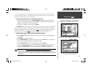
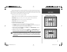
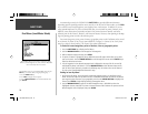
In an emergency, a list of nearest airports is readily available by
pressing the NRST key.
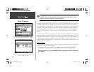
The ‘Wx’ tab lists nearby airport-based weather information.
190-00283-00Backup.indd 49 12/8/2002, 8:09:16 PM