


Chapter 5 Command Reference
GPS Satellite Acquisition
Operating and Programming Guide 5-17
Selecting Satellites _______________________________________
This command instructs the Receiver to allow tracking those satellites for
which the elevation angle is greater than this elevation mask angle. Satellites
below this elevation are visible, but will not be tracked.
Expanded Syntax
:GPS:SATellite:TRACking:EMANgle <degrees>
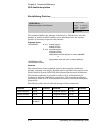
Parameter
<degrees> range is 0 degrees (horizon) to 89 degrees. The resolution is
1 degree.
The maximum recommended value while the position is being surveyed is
15 degrees, to allow tracking of four satellites needed for an accurate position
determination.
Once the survey is complete, the elevation mask angle can be increased to avoid
interference problems caused by buildings and trees and minimize effects of
multipath, if necessary.
Values above 40 degrees severely limit GPS signal availability, and are not
recommended.
This query returns the GPS elevation mask angle value.
Response
The range is 0 degrees to 89 degrees.
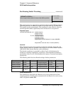
:GPS:SATellite:TRACking:EMANgle . . .
:SYSTem:PRESet
Sets the GPS elevation mask angle value (in degrees).
10
NON-VOLATILE
:GPS:SATellite:TRACking:EMANgle?
RESPONSE FORMAT
Returns the GPS elevation mask angle value.
±
dd