


Chapter 5 Command Reference
GPS Satellite Acquisition
5-12 Operating and Programming Guide
Establishing Position_____________________________________
This command defines the position of the Receiver. The Receiver uses this
position to predict satellite visibility and to determine time. An accurate
position is necessary for precise time transfer.
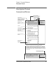
Expanded Syntax
:GPS:POSition N or S, <latitude degree>,
<latitude minute>,
<latitude second>,
E or W, <longitude degree>,
<longitude minute>,
<longitude second>,
<height above the GPS ellipsoid, in meters (58303B)>
or
<height above mean sea level, in meters (59551A)>
:GPS:POSition LAST
:GPS:POSition SURVey
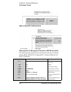
Parameter
The numeric form of this command requires three position coordinates:
latitude, longitude, and height. Position must be specified with respect to the
World Geodetic System 1984 (WGS-1984) datum absolute earth coordinates.
The latitude coordinate is preceded by either N or S, which denotes the
northern or southern hemisphere, respectively. The longitude coordinate is
preceded by either E or W, which denotes the eastern or western hemisphere,
respectively.
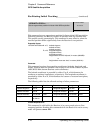
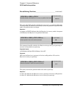
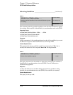
The following table lists the allowed settings of other parameters:
:GPS:POSition . . .
:SYSTem:PRESet
Defines the position of the Receiver.
latitude: N 0:00:00.000
longitude: E 0:00:00.000
height: 0 meters
NON-VOLATILE
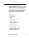
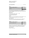
Parameter Range Precision Parameter Range Precision
<latitude degrees> 0 to 90 1 <longitude degrees> 0 to 180 1
<latitude minutes> 0 to 59 1 <longitude minutes> 0 to 59 1
<latitude seconds> 0 to 59.999 0.001 <longitude seconds> 0 to 59.999 0.001
<height, m> -1000.00 to
18,000.00
0.01