


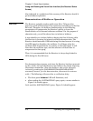

Chapter 3 Visual User Interface
Using and Reading the Visual User Interface (the Receiver Status
Screen)
3-6 Operating and Programming Guide
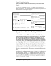
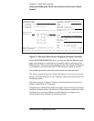
Also, you can see the initial (estimated) position has been replaced
with a computed position, which the Receiver continuous to refine until
it gets a very accurate position. The status screen indicates that a
computed position is being used by displaying the averaged latitude,
and longitude height (AVG LAT, AVG LON, and AVG HGT).
If the position were not precise, GPS timing information would be
inaccurate by an amount corresponding to the error in the computed
position. An error in the computed position of the antenna translates
into an error in the derived time and will compromise the Receiver’s
ability to be a timing source.
Let’s consider a case where four satellites are not visible at powerup
because of a poor antenna location, such as an “urban canyon” (located
between tall city buildings). If accurate position is known from a
Geodetic survey of that site, it can be programmed with the position
command, thereby bypassing the survey operation. This is useful when
four satellites cannot be tracked for an extended period of time.
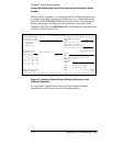
Let’s send the
:SYSTEM:STATUS?
query again to observe the current
status of the Receiver.
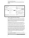
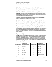
The updated demonstration status screen in Figure 3-3 indicates that
the position survey is now 5.4% complete. Thus, the survey task is
beginning to iterate toward an accurate position. In the Time
quadrant, the UTC time is now correct. The date is correct, and the
GPS reference signal is synchronized to UTC.