


Rev. D 3 — Basic Navigation
3 — Basic Navigation3 — Basic Navigation
3 — Basic Navigation Page 23
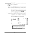
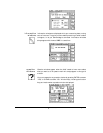
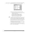
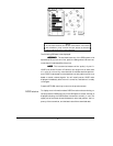
The image of your boat displayed on the screen points in the direction of
your Course-Over-Ground. Remember, this direction may be different
from your heading. The boat image shows your actual direction of travel
over the bottom, not the direction your boat is headed. If your boat is not
moving, the Course-Over-Ground cannot be determined by the 941X,
and the direction of the boat on the screen has no meaning.
Avoidance areas (waypoints for which a warning radius has been speci-
fied) are shown as a circle surrounding the waypoint.
Your present Speed-Over-Ground (SOG) and Course-Over-Ground
(COG) are displayed at the bottom of the screen, along with the chart
scale. The chart scale is the distance from the top edge to the bottom
edge of the plot.
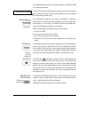
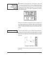
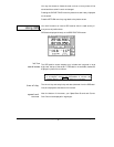
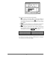
Press the
ZOOM IN
menu key to zoom in for a closer look at the area in
the center of the screen. Press the
ZOOM OUT
menu key to zoom out to
see more area. Each press of the
IN
or
OUT
key approximately halves or
doubles the chart scale, respectively.
The maximum zoom-in screen displays an area that is approximately ¼-
mile from the top edge to the bottom, while maximum zoom-out shows
you an area that is up to 128 miles, top to bottom.
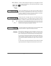
Press the
CENTER
menu key at any time to move the plotted area so
that your boat is at the center of the screen.
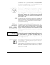
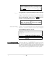
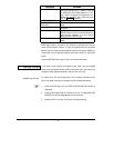
If you wander off your intended course line, and you want to navigate
directly to the waypoint rather than returning to the original course line,
press the
RESTART
menu key, then
ENTER
. A new course line will be
computed and displayed, running from your present position to the next
waypoint.
NOTE:
The plotter screen can be used to steer by when the objective is
simply to get to the waypoint without needing to remain pre-
cisely on the designated course line.
zooming
centering the
plot
course restart