


90
Owner's Manual
GPS
Zoom-In
Shows more detail in a smaller area.
Zoom-Out
Operates similarly to zoom -in, but in the reverse, showing a wider but less
detailed view.
XTE = Cross Track Error
Distance from the ship's present position to the closest point on a line
between the origin and destinations Waypoints of the navigation.
9.2. GPS
For centuries, sailors have been searching for a reliable and precise method
of traveling the world's waterways. From celestial navigating to the modern
navigation techniques as Loran, Decca Navigator, Omega or Transit Satnav,
each system has had its problems with weather, range and reliability. Without
doubt, the "Global Positioning System", or GPS for short, is the most
significant advance in navigation: it gives the navigator a position 24 hours a
day, 365 days a year in any weather condition.
GPS is a satellite based navigation system which provides suitably equipped
users with accurate position, velocity and time data.
Originally the GPS, developed by the U.S. Department of Defense, was
conceived for military purposes, but now it is used in a host of civilian
applications.
GPS navigation uses satellite signals to determine your position in relation to
a set of satellites orbiting the earth. The GPS constellation of satellites
continuously send radio signals, containing the precise position for each
satellite back to earth. By knowing the position of 3 or 4 satellites and
calculating various time differences between transmitted signals, the GPS
receiver can determine its present position anywhere on earth, and thanks to
continuous updates, calculate speed and course information.
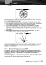
9.2.1. How GPS Works
Currently, the GPS constellation consists of 26 orbiting satellites (including 3
spares), but this number will increase in the future.
The GPS receiver computes an accurate position by calculating the distance
to the GPS satellites that orbit the earth. Signals are required from 3 satellites
for two dimensional (2D) position calculation whilst 4 satellites are required for
three dimensional (3D) position calculation.
As mentioned earlier, GPS satellites are not geostationary, but they are
orbiting the earth as illustrated on the following figure: