


Nothing Comes Close to a Cobra
®
11
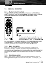
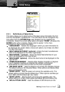
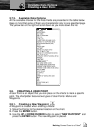
2.2.1. Definitions of Selections
This menu allows you to select some of the basic setup information the first
time the chartplotter is powered On. This information can be changed at any
time either from the SYSTEM Page (see Chapter 5) or by resetting the
chartplotter. Select the correct setup option and select “DONE” and press the
ENTER button when complete. Please refer to section 1.2 for more
information on how to enter information.
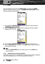
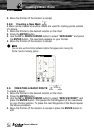
“LANGUAGES” - Selects the language in which you wish information to
be displayed (for screen labels, menus and options, but it does not affect
the map information).
“BOAT MANUFACTURER” (optional) - Enters the boat manufacturers
name to be displayed on the initial Logo Screen.
“BOAT MODEL” (optional) - Enters the Model Name/Number of your
boat to be displayed on the Logo Screen.
“BOAT NAME” (optional) - Enters the boat name to be displayed on the
Logo Screen.
“COMPASS BEARINGS” - Selects either degrees magnetic or degrees
true. If magnetic readings are selected the variation is computed
automatically for every zone as soon as the chart is displayed.
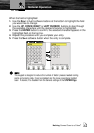
“DISTANCE UNITS” - Sets the distance unit among the available choices.
The default setting is Nm (Nautical Miles). Other options are Statute Miles
(Sm) and Kilometers (Km).
“SPEED UNITS” - Sets the speed unit among the available units. The
default setting is Knots (Nautical Miles/Hour). Other options are Miles per
Hour (Mph) and Kilometers per Hour (Kph).
“DEPTH UNITS” - Sets the depth units among the available units. The
default setting is Ft (Feet). Other options are Meters (Mt) and Fathoms (Ft).
“GPS ALTITUDE UNITS” - Sets the altitude of GPS Antenna on the
Initial Setup