


30
Owner's Manual
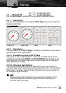
3.5. HIGHWAY PAGE
Whenever it is activated the HIGHWAY Page uses the most relevant
navigation information to provide digital and graphical steering guidance to the
destination.
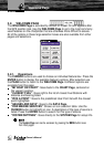
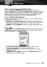
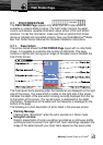
3.5.1. Description
The picture below shows the layout of the HIGHWAY Page with 4 data fields
and a steering compass above the Horizon. The data fields and steering
compass are shown by default. It is possible to customize all fields shown in
the HIGHWAY Page, as described later in this section. The central section of
the screen provides visual guidance to the Waypoint on a graphical “highway
display”, and the bottom of the page is designed for navigation data display.
The line down the center of the highway represents the desired track line.
The distance between a vessel and a Target can be changed using the ZOOM IN
and ZOOM OUT buttons. The distance from the center line to the side of the
highway is indicated on the display.
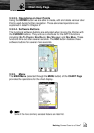
As a vessel heads towards its destination, the highway perspective moves to
indicate progress to the Waypoint and the proper direction which should be
kept to stay on course. If a navigation Route is defined, the HIGHWAY Page
shows each Waypoint of the Route in sequence. “Clouds” are shown during
the day and “Stars” for when night mode is set.
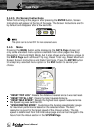
3.5.2. Operations
The HIGHWAY Page provides access to functions and features using the
MENU button and software button options.
Highway Page