


Nothing Comes Close to a Cobra
®
63
strength of the current changes throughout the day.
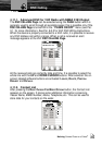
“PORTS AND SERVICES”: Turns ON or OFF the displaying of the Ports
and Services (areas along shore with facilities for mooring, downloading
and uploading of ships, generally sheltered from waves and winds. Port
installations are piers, wharves, pontoons, dry docks, cranes, etc).
“TRACK AND ROUTES”: Turns ON or OFF the displaying of the Tracks
and Routes (recommended and established routes for ships at sea,
including traffic separation schemes, deep water routes). Please note that
these are not the same Tracks and Routes that you record and plan on
your chartplotter. They are part of the chart and turning them off will
choose not to show them on your screen.
“VALUE ADDED DATA”: Turns ON or OFF the displaying of the Value
Added Data. The Value Added Data (VAD) is a collection of additional
cartographic objects which are not present on the original paper chart
(from which the electronic chart derives). These objects have been
obtained from other sources (that C-MAP believes to be reliable) and then
merged to the electronic charts in order to provide more information useful
for the navigation.VAD object can be any cartographic objects and it can
be distinguished from the official-chart-objects from the Quick Info. A
dedicated icon is shown on the Quick Info window to indicate that the
object queried is a VAD. The same icon is also shown on the Full Info
page and in addition the extended text Value Added Data is shown on the
details of the VAD object.
“ADVANCED CHART SETTINGS”: Selects the ADVANCED CHART
SETTINGS menu, see the Par. 5.2.2.4.
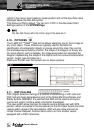
5.2.2.2. Depth Presentation
To control the display on the map of the depth information.
After the CHART SETTINGS menu is shown:
1. Use the UP or DOWN CURSOR button to select “DEPTH
PRESENTATION” and press the ENTER button.
2. Use the UP or DOWN CURSOR button to select the desired option and
then press the ENTER button. The available options are listed below:
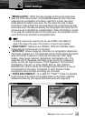
“SHADED DEPTH AREAS”: Turns ON or OFF the shading of desired
depth areas with reference to defined minimum and maximum depth
values.
“DEPTH RANGE MIN”: Sets a minimum reference for the Depth Areas.
“DEPTH RANGE MAX”: Sets a maximum reference for the Depth Areas.
“ROCKS MIN”: Sets a min reference rocks value.
“ROCKS MAX”: Sets a max reference rocks value.
Chart Settings