


26
Owner's Manual
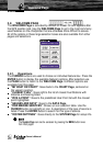
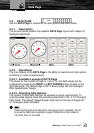
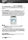
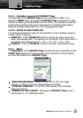
MAIN
“STOP NAVIGATION”: Stops navigation to destination, if Target is set.
“3D VIEW”: Changes from standard to 3D mode. This could also be used
to choose viewing angle.
“DYNAMIC NAV AIDS”: Turns ON or OFF the blinking lights on Nav-Aids.
“NIGHT MODE”: Toggles the color setting in color pallets directly between
the current daytime color pallet and night mode.
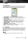
“MAP ORIENTATION”: Selects the orientation of your chart according to:
North Up (the map is shown with North upwards), Heading Up (the map is
shown with the ship's current heading upwards), Course Up (the map is
displayed with the currently selected course leg upwards).
“FONTS AND SYMBOLS”: On MAX charts it is possible to set the size of
all names and symbols drawn on the charts, selecting between Normal
size (the regular characters size) and Large size.
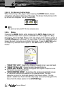
“CURRENT PREDICTIONS”: Shows the variation of the Tidal arrows on
the selected area at any given time. See also Par. 4.8
“MEASURE”: Allows measuring Distance and Bearing between two points
on the CHART Page. See also Par. 4.1.
“FIND”: The same as pushing the Find button. See Par. 2.11.
“TRACKS”: Allows the management of the Track. See also Par. 4.4.
“ROUTES”: Allows the management of the Route. See also Par. 4.3.
“USER POINTS LIST”: Selects the User Points List Page with information
on all stored User Points. See also Par. 4.6.
“USER C-CARD”: Allows the management of the User C-CARD . See
also Par. 4.6.
“ADVANCED CHART SETUP”: Goes directly to the System Menu and
into the Chart Settings.
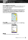
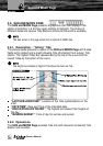
DATA FIELDS
“CHANGE DATA FIELD”: Any data field can be highlighted and changed
to any available data option.
“STEERING COMPASS”: Enables or disables the display of the Steering
Compass in the top of the CHART Page.
“NUMBER OF DATA FIELDS”: Sets the number of fields displayed on
the CHART Page.
“ADVANCED DATA SETUP”: Goes directly to the System Menu and into
the Units menu.
The ESC button always bring you to the center of the chart.
Chart Only Page