


88
Owner's Manual
RTCM = Radio Technical Commission for Maritime Services
The data format created by the Radio Technical Commission Maritime to
transmit Differential GPS corrections.
SNR = Signal to Noise Ratio
Ratio between the magnitude of a radio signal and the magnitude of the
noise (that is, the interferences). The SRN is expressed in decibels and it
is associated to the GPS satellites signal quality.
SOG = Speed Over Ground
Current velocity at which the vessel is traveling, relative to a ground
location. The SOG is normally provided by the GPS sensor.
SPD = Speed Through Water
Speed of the vessel relative to the water.
Spot Sounding
Depth of the water in a specific and charted position. It is represented on
the map by its own value expressed in the current depth unit.
STR = Steering
Difference between COG and CTS. If COG is 25° and CTS is 30°, then
STR is 5° Right.
TD = Time Difference
Loran positions are determined by precise timing of the intervals between
reception of pulses transmitted by pairs of stations in the selected chain.
Between any two stations a ship must be located somewhere along a line
of possible positions where the measured Time Difference, TD, between
arrival of pulses from those stations would be observed. The TD is
measured from the time of reception of the master station signal to the
time of reception of the slave station signal (see also Pair).
Tide
Periodic rise and fall of the surface of oceans, bays, etc., due principally to
the gravitational interactions between the Moon and Earth.
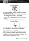
Tide Info
The Tide Info feature is the combination of a new Tide heights database that
will be included within new C-CARDs and new features which calculate the
Tide graph for all primary and secondary ports world-wide. This function can
calculate the Tide heights for any past or future date and as a by-product of
this calculation will also display the Maximum and Minimum Tide height and
time for the day selected plus the times of Sunrise and Sunset. At some chart
levels, the chartplotter will display a new Tide Diamond Symbol for every Port
or Tide point in the database covered by that particular C-CARD.
Tracks + Routes
Recommended and established routes for ships at sea, including traffic
separation schemes, deep water routes.
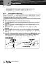
Terms