


46
Owner's Manual
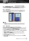
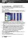
3.10. GPS PAGE
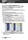
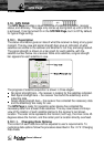
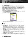
The GPS Page provides a visual reference of satellite acquisition, receiver
status, and accuracy. This page only comes up during boot up until a GPS fix
is achieved. It can be turned On in the SYSTEM Page, but it is Off by default,
for typical Page surfing.
3.10.1. Description
The status information gives an idea of what the receiver is doing at any given
moment. The sky view and signal strength bars give an indication of what
satellites are visible to the receiver and whether or not they are being tracked.
The signal strength is shown on a bar graph for each satellite, with the
satellite number below. As a receiver locks onto satellites, a signal strength
bar appears for each satellite in view.
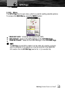
The progress of satellite acquisition is shown in three stages:
No signal strength bars – the receiver is looking for the satellites indicated.
Red signal strength bars – the receiver has found the satellite(s) and is
collecting data
Green signal strength bars – the receiver has collected the necessary data
and the satellite(s) are ready for use.
The GPS Page is ready for navigation when device has collected the
necessary data from at least three satellites. The sky view shows a bird-eye
view of the location of each satellite relative to the receiver’s last known
location. The outer circle represents the horizon (north up), the inner circle 45
degrees above the horizon, and the center point a location directly overhead.
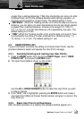
3.10.1.1. Changing Data Options
The content of each data box can be adjusted to user’s requirements. To
customize data options follow the procedure described in Par. 2.7.2 Changing
Data Fields.
GPS Page