


Chapter 4: Using the Chartplotter 63
4.3 What is Displayed
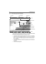
The chartplotter has a built in world map. Most areas are displayed at a scale of 72
nm from the top to the bottom of the screen and can be overzoomed as desired.
Electronic Charts
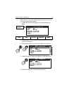
To use the chartplotter as a navigation aid, you need chart cards containing
detailed information for the area you wish to navigate. These cards are available
from Navionics. See Chapter 1: Using the Display. For full information on installing
and removing chart cards refer to Chapter 2: General Operation and System
Setup
.
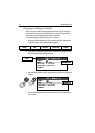
You can remove and insert cards while a chart is displayed. The chart information
is retained on-screen until the chartplotter redraws the screen, such as when you
pan outside the current area or use the RANGE key to change the chart scale.
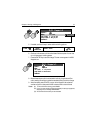
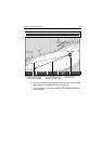
The amount of detail shown varies for different areas and for different scales. The
chart scale in use is indicated in the status bar; the number represents the distance
in nautical miles from the top of the chart window to the bottom of the chart
window.
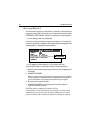
Chart Orientation and Relative Motion
You can change the way the chart is drawn in relation to your boat’s position by
changing the orientation and Relative Motion mode.
The orientation of the chart refers to the relationship between the chart and the
direction that you are travelling in. Your system is set to move the ship’s heading
marker as the heading changes (North-Up). This can be changed to Course-Up or
Head-Up if so desired.
The Relative Motion mode controls the chart-to-boat movement. Relative Motion
is set when your boat’s position is fixed and the chart moves across the screen.
This can be changed so that your boat moves and the chart is fixed. The latter
mode is called true motion. See “Setting the Chart Orientation“ on page 88
and“Relative Motion“ on page 89 for more detailed information.