


30 A65 GPS Chartplotter
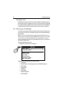
Navigate to ‘More’ and right-press the trackpad to access additional selections.
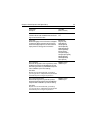
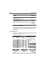
Spot Soundings
Number on the chart indicating depth.
OFF
ON
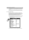
Safety Contour
Areas with depths shallower that the specified value are shaded
in a different color than those areas with depths greater than
the specified value. The contour is always drawn at or deeper
than the selected depth.
OFF
7ft
16ft
33ft
66ft
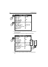
Depth Contour
Outlines an area that is located at the specified depth.
OFF
16ft
33ft
66ft
ALL
Nav. Marks
Navigation marks.
OFF
ON
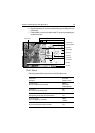
Nav. Marks Symbols
The set of symbology used for navigation marks.
Corresponds to paper charts.
INTERNATIONAL
US
Light Sectors
The sector of light cast by a fixed beacon.
OFF
ON
Caution & Routing Data
Magenta-colored lines indicating route for safe passage and
outlining areas to avoid.
OFF
ON
Marine Features
The cartographic features that are displayed on the water.
OFF
ON
Land Features
The cartographic features that are displayed on the land.
OFF
ON
FUNCTION
Description
OPTIONS
(Default in
bold)