


Chapter 4: Using the Chartplotter 65
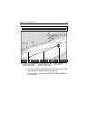
Find Ship
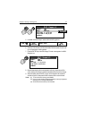
Your boat is represented on screen by a ship symbol. If you cannot see your boat
(it has travelled off-screen), press FIND SHIP. The chart is redrawn with your boat
and the cursor in the center of the screen. Actually, the location of the boat on the
screen depends on the current motion mode. (See “Relative Motion“ on
page 89.) Details of your boat’s position is displayed in the Status Bar and the
selected motion mode is reinstated. After five seconds of inactivity, the cursor
disappears. As long as you do not press the trackpad or rotary knob, the position
of your boat is fixed on the screen and the chart picture moves relative to your
boat. When you again press the trackpad or rotary knob, the cursor reappears, the
chart is fixed and the boat moves in perspective to fixed objects on the screen.
Notes: (1)
If neither heading nor COG data is available, the vessel is shown as a circle.
(2)
To mark your current position with a waypoint, please refer to the
Waypoints chapter.
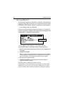
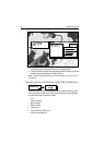
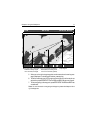
Chart Card
The chart card includes details of each cartographic object that is marked on the
chart. They also contain source data for structures, lines, open sea areas, port
services and tide information.
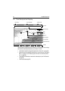
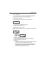
1. Make sure you have enabled the Cursor Info setting (see page 23).
2. Move the cursor over a cartographic object. The cursor turns red and basic
information relating to that object is displayed. Over an area of water or land
not containing a cartographic object, the chart source data is displayed.
D6627-1