


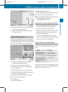
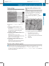
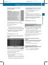

Display settings
You can select what kind of traffic information
is displayed on the map.
X
Select Navi Q Traffic Symbols on
Map
X
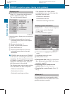
Displaying traffic incidents: Select
Incidents.
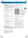
Road sections for which traffic incidents
are reported are indicated by yellow
symbols and arrows.
X
Displaying traffic speed and flow: Select
Speed & Flow.
Road sections for which traffic
obstructions are reported are indicated by
yellow or red vehicle symbols.
X
Displaying normal traffic flow: Select
Free Flow.
Road sections with reported free flowing
traffic are indicated as green lines.
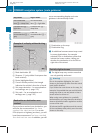
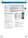
Real-time traffic notifications in the
map
COMAND can display certain traffic events in
the map. The notifications are shown in the
map scale range from
1
/
16
mi to 20 mi.
Free Flow traffic messages are only
displayed with a map scale of
1
/
16
miles to
5 miles.
X
Set the required map scale (Y page 102).
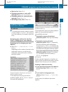
1, 2
Marker symbols for the extension of
the affected route section
3
Symbol for event on the route
4
Current vehicle position and direction
of travel
A
Map scale
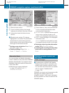
Real-time traffic notification symbols
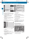
i
Red and yellow cars and green and yellow lines appear on the map when Speed & Flow,
Free Flow, or Incident are selected via Navi Q Traffic Symbols on Map.
The diamond shaped icons appear when Traffic Q Traffic Symbol Info is selected
from the map submenu.
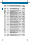
COMAND navigation system (real-time traffic)
139
Control systems
221_AKB; 6; 20, en-US
d2ugruen, Version: 2.11.8.1
2009-09-24T13:28:17+02:00 - Seite 139
Z