


Loran TD
Loran TD System
LORAN-C is a radio navigation aid operated and maintained in the United States by the United
States Coast Guard. The name LORAN is an acronym for “LOng RAnge Navigation”. The LORAN
system covers the entire United States and the U.S. Coastal Confluence Zone. From the perspective of
a mariner, the system is used for ocean and coastal navigation. It can be used as a supplemental system
for harbor and harbor approach navigation, and it is used for inland navigation by recreational vehicles.
LORAN TD Feature
The LORAN TD (Time Delay) feature eases the transition from using LORAN to using GPS. The
GPSMAP unit automatically converts GPS coordinates to LORAN TDs for those who have a collec-
tion of LORAN fixes for favorite fishing spots and other waypoints recorded as TDs. You can display
your position as a TD or enter waypoints as TDs. The accuracy to be expected from this conversion is
approximately thirty meters. When the unit is placed in the LORAN TD format mode, it simulates the
operation of a LORAN receiver. Position coordinates may be displayed as TDs, and all navigation func-
tions may be used as if the unit was actually receiving LORAN signals.
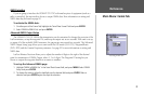
Using the LORAN TD Format
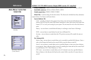
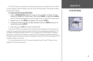
When creating new waypoints using LORAN TD coordinates, you must set the correct LORAN
chain number and secondary stations in the Setup TD field before storing the waypoint. You must have
the correct chain number as well as the secondary station identifiers to use this option correctly. These
values varies per coordinate set or geographical location. Failure to enter correct information could
result in inaccuracies for the desired destination. After the waypoint is stored in unit memory, it always
references the LORAN chain number and secondary stations currently selected in the Setup TD field.
If you enter a different LORAN chain number, change the secondary stations or offsets in the Setup TD
field, the active waypoint information reflects those changes. Since the GPSMAP unit does not rely on
the LORAN signal for navigation, it can reference a different GRI chain and/or secondary stations and
still navigate to the location stored in memory.
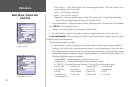
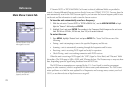
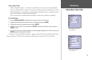
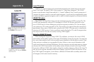
On the Units Tab of the Main Menu, press
MENU, then highlight ‘Loran TD On’ and
press ENTER to select Loran TD.
Or, highlight the Position Format field,
highlight ‘Loran TD’ and press
ENTER to
select Loran TD.
78
Appendix A