


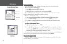
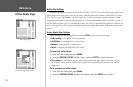
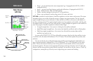
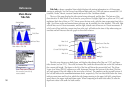

Sky View
Signal
Strength
Bars
Receiver
Status
Differential
Status
Accuracy
45°
90°
Outerring -
thehorizon
Innerring- 45°
abovethe horizon
Centerdot -90°
abovethe horizon
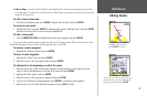
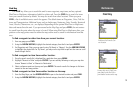
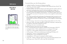
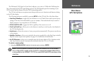
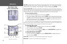
Main Menu— GPS Tab
Main Menu:
GPS Tab
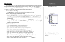
• Temp* – sets up and shows the water temperature log. (if equipped with GSD 20 or NMEA
compatible device)
• Sonar* – sets up Sonar Page features, speeds and calibrations. (if equipped with GSD 20)
• Setup – defines System, Units, and Time settings.
• Comm – interface settings for use with a PC or second device.
• Alarm – sets up alarms for anchor drag, arrival, off course, and clock.
GPS Tab— provides a visual reference of satellite acquisition, receiver status, and accuracy. The status
information gives you an idea of what the receiver is doing at any given moment. The sky view and
signal strength bars give you an indication of what satellites are visible to the receiver and whether or
not they are being tracked. The signal strength is shown on a bar graph for each satellite, with the satel
-
lite number below. As the receiver locks onto satellites, a signal strength bar appears for each satellite in
view. The progress of satellite acquisition is shown in three stages:
• No signal strength bars— the receiver is looking for the satellites indicated.
• Light/White signal strength bars— the receiver has found the satellite(s) and is collecting data.
• Dark/Green signal strength bars— the receiver has collected the necessary data and the
satellite(s) are ready for use.
As soon as the GPSMAP 172/172C has collected the necessary data from the best satellites in view
to calculate a fix, the status field indicates a 2D or 3D status. The unit then updates the position, date
and time.
You can use the sky view to help determine if any satellites are being blocked, and whether you
have a current position fix (indicated by a ‘2D’,‘2D Differential’,‘3D’, or ‘3D Differential’ in the status
field). The sky view shows a bird’s-eye view of the position of each satellite relative to the receiver’s
last known position. The outer circle represents the horizon (north up), the inner circle 45º above the
horizon, and the center point a position directly overhead. You can also set the sky view to a ‘Track Up’
configuration, causing the top of the sky view to align along your current track heading.
54
Reference