


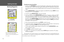
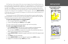
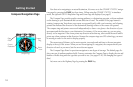
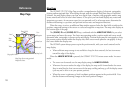
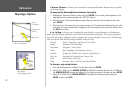

Map Page
The GPSMAP 172/172C’s Map Page provides a comprehensive display of electronic cartography,
plotting and navigational data. When using the unit with the optional BlueChart data or MapSource
software, the map display shows your boat on a digital chart, complete with geographic names, map
items, navaids and a host of other chart features. It also plots your track and displays any routes and
waypoints you create. An on-screen cursor lets you pan and scroll to other map areas, determine the
distance and bearing to a position, and perform various route and waypoint functions.
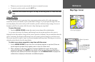
When the cursor is active, an additional data window appears below the data fields to indicate the
position, range and bearing to the cursor or a selected waypoint or map item. The map scale displays at
the bottom right of the page.
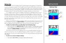
The (ZOOM) IN and (ZOOM) OUT keys, combined with the ARROW KEYPAD, let you select
zoom ranges and move the cursor. Two basic map operating modes, position mode and cursor mode,
determine what cartography is shown on the map display. Position mode pans the cartography to keep
the present position marker within the display area, while cursor mode pans the cartography to keep
the cursor within the display area.
The GPSMAP system always powers up in the position mode, with your vessel centered on the
map display.
• When sufficient map coverage is not available to keep the boat centered, the boat icon moves
toward the edge of the display.
When the ARROW KEYPAD is pressed, the GPSMAP 172/172C enters cursor mode. In cursor
mode:
• The cursor can be moved over the map display using the ARROW KEYPAD.
• Whenever the cursor reaches the edge of the display, the map scrolls forward under the cursor.
Keep in mind that the boat icon moves with the map scrolling and may go off the display screen
(you may not be able to see your present position).
• When the cursor is stationary, a fixed coordinate position appears in the position field. Note
that the distance and bearing changes as the boat’s position changes.
Data Fields
Boat Icon
Map Scale
Land
Water
Geographic Name
Map
Item
Navaids
User
Waypoint
Map Page shown using optional
MapSource data.
18
Reference
Map Page