


SECTION 6
GPS Receiver
Reference
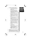
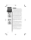
To select AutoLocate, highlight ‘AutoLocate’ and
press ENTER.
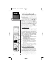
Initialize Position - designates your approximate
position in order to speed up satellite acquisition. This
option may be used instead of AutoLocate.
To initialize your starting position:
1. Highlight Initialize Position and press ENTER
2. Designate your approximate position on the map using the
arrow keypad and press ENTER. (You may wish to use the
zoom keys to adjust the level of detail displayed, as you
determine your approximate position.)
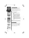
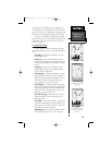
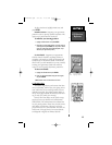
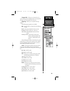
Set 2D Altitude - designates your approximate
altitude, when the NavTalk is acquiring satellites or
navigating in 2D mode. By default, 2D navigation will
attempt to use the last known altitude. If the altitude
shown is off by several hundred feet or more, manually
entering your approximate altitude will enable the
receiver to more accurately determine a position fix..
To enter an altitude:
1. Highlight Set 2D Altitude and press ENTER
2. Enter your approximate altitude using the arrow keypad,
and press ENTER.
NOTE: Altitude canot be entered while in 3D mode.
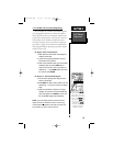
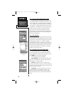
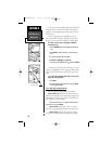
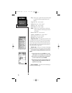
6.2 Position Page
The Position Page shows your location, what direc-
tion you’re heading, and how fast you’re going, and it’s
most useful when you are traveling without an active
destination waypoint. The graphic heading display at
the top of the page indicates the direction you’re head-
ing, or track (only while you’re moving).
Directly below this display are the speed, average
speed, trip timer, trip odometer and sunrise/sunset
fields (default). The sunrise/sunset times indicated are
for your present position. These times, and the current
time display at the bottom of the page, can be dis-
played in local or UTC (universal) time. The lower left-
hand corner of the page shows your current latitude
and longitude in degrees and minutes (default).
Position Page
Set 2-D Altitude
“Pop-Up” Screen
65
NvTlkGPS.qxd 2/1/00 4:13 PM Page 5